Hobart Airport (HBA)
Driving Directions / Travel by Car
(Hobart, Tasmania - TAS, Australia)
Located on the western side of Hobart city centre, Hobart Airport (HBA) is situated to the south of the Pitt Water area of the Tasman Sea, below the Sorel Causeway, which connects to the Tasman Highway. Hobart Airport is particularly close to Seven Mile Beach to the south, Cambridge to the west, and Midway Point to the north.
Notable roads in the region surrounding Hobart Airport include Pittwater Road, which borders the eastern side of the airport and leads to Surf Road, along the coastline. The Tasman Highway is a major road on the northern edge of Hobart Airport and runs in a north-easterly direction, being intersected by numerous smaller roads, such as Kennedy Drive and Holyman Avenue, leading to the terminal.
A number of attractions are close to Hobart Airport, such as the nearby Cambridge Aerodrome to the north-west, and the sandy stretches of beachfront, lying in a southerly direction. Within Hobart Airport itself, the main thoroughfares include Tower Road, Back Road, Addison Drive and Gatty Street. Here are some useful directions to the airport.
Directions to Hobart Airport (HBA) from Hobart city centre:
- Hobart Airport (HBA) is situated 17 km / 10.5 miles to the east of Hobart city centre
- The airport has good connections to area's highway network and is well signposted
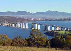
- Major roads that travel to Hobart Airport include the busy road spanning the famous Tasman Bridge
- A street map of the Hobart area is often a good idea when driving to the airport
- The journey from Hobart city centre to the airport should take around 30 minutes
- When travelling to Hobart Airport during the rush hours (07:30 to 10:00 and 16:00 to 18:00), be sure to allow extra time for the possibility of traffic delays
Hobart International Airport (HBA): Virtual Google Maps
